 The Overlay Layers tool combines two layers into a single layer using one of two methods: Intersect or Erase.
Workflow diagram

Analysis using GeoAnalytics Tools
Analysis using GeoAnalytics Tools is run using distributed processing across multiple ArcGIS GeoAnalytics Server machines and cores. GeoAnalytics Tools and standard feature analysis tools in ArcGIS Enterprise have different parameters and capabilities. To learn more about these differences, see Feature analysis tool differences.
Examples
The department of environmental quality wants to monitor the impact of livestock grazing on the state's water quality. Biologists with the department need to determine where the land deemed to be grazing allotments intersects with certain watersheds. Overlay Layers can be used to find intersecting areas.
A development company wants to build a new golf resort in one of three centrally located counties in their state. Before they can begin planning, they need to determine whether there is enough privately owned land within those counties available to purchase for the resort. Overlay Layers can be used to remove the publicly owned lands from the selected counties.
Usage notes
Sliver features may be excluded based on the tolerance of the processing spatial reference.
The Overlay Layers tool requires two inputs: an input layer and an overlay layer. The input and overlay layers must have the same geometry. The two methods are described in the following table:
| Overlay method | Input features | Overlay features | Description |
|---|---|---|---|
Intersect
| Points, lines, or areas | Points, lines, or areas | The features or portions of features in the overlay that overlap with the input features are kept. The input and feature geometry must be the same. The output is the same geometry as the input and overlay features. This is the default method. |
Erase
| Points, lines, or areas | Points, lines, or areas | The features or portions of features in the overlay features that overlap with the input features are removed. |
The following table outlines the overlay operations, Intersect and Erase, with different geometry types:
| Input layer (green) and overlay layer (yellow) | Intersect results | Erase results |
|---|---|---|
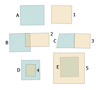 Polygon overlay layer (green) and input layer (yellow). | 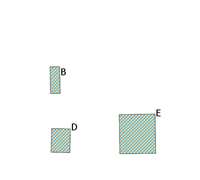 Intersecting polygons of the input and overlay layers. B is the intersection of B and 2. D is the intersection of D and 4. E is the intersection of E and 5. | 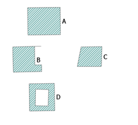 Polygons that are the result of the Erase operation. E has been completely erased, and a portion of B and D have been erased. A and C have not been erased. |
 Line overlay layer (green) and input layer (yellow). |  Lines that are the result of the Intersect operation. B is the intersection of B and 2. D is the intersection of D and 4. |  Lines that are the result of the Erase operation. The feature B has been completely erased, and a segment of D has been erased. A and C have not been erased. |
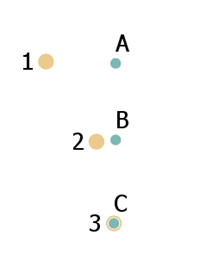 Point overlay layer (green) and input layer (yellow). |  Point that is the result of the Intersect operation. C is the intersection of C and 3. | 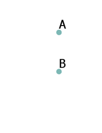 Points that are the result of the Erase operation. The feature C has been erased. A and B are the result of the operation. |
If Use current map extent is checked, only the features in the input and overlay layer that are visible within the current map extent will be overlaid. If unchecked, all features in both the input layer and the overlay layer will be overlaid, even if they are outside the current map extent.
ArcGIS API for Python example
The Overlay Layers tool is available through ArcGIS API for Python.
This example finds the intersecting areas between watersheds and grazing land in Missouri. # Import the required ArcGIS API for Python modules
import arcgis
from arcgis.gis import GIS
from arcgis.geoanalytics import manage_data
# Connect to your ArcGIS Enterprise portal and check that GeoAnalytics is supported
portal = GIS("https://myportal.domain.com/portal", "gis_publisher", "my_password", verify_cert=False)
if not portal.geoanalytics.is_supported():
print("Quitting, GeoAnalytics is not supported")
exit(1)
# Find the big data file share dataset you're interested in using for analysis
search_result = portal.content.search("", "Big Data File Share")
# Look through search results for a big data file share with the matching name
bd_file = next(x for x in search_result if x.title == "bigDataFileShares_LandUse")
# Look through the big data file share for grazing land
grazing_land = next(x for x in bd_file.layers if x.properties.name == "GrazingLand")
# Find a feature layer named "Watersheds" in your ArcGIS Enterprise portal and apply a filter
watersheds = portal.content.search("Watersheds", "Feature Layer")
watersheds_layer = layer_result[0].layers[0]
watersheds_layer.filter = "region = 'Missouri'"
# Set the tool environment settings
arcgis.env.verbose = True
arcgis.env.defaultAggregations = True
# Run the Overlay Layers tool
overlay_result = manage_data.overlay_data(input_layer = grazing_land,
overlay_layer = watersheds_layer,
overlay_type = "Intersect",
output_name = "Watershed_intersections")
# Visualize the tool results if you are running Python in a Jupyter Notebook
processed_map = portal.map('Missouri', 6)
processed_map.add_layer(overlay_result)
Similar tools
Use Overlay Layers to combine two layers into a single layer using the Intersect or Erase method. Other tools may be useful in solving similar but slightly different problems.
Map Viewer analysis tools
If you want to overlay layers using the union relationship, use the standard analysis tool Overlay Layers.
If you are combining features of the same type into a single feature layer regardless of the spatial relationship, use the standard tool Merge Layers.
ArcGIS Desktop analysis tools
Overlay Layers performs the function of the Intersect and Erase tools.
To run this tool from ArcGIS Pro, your active portal must be Enterprise 10.6.1 or later. You must sign in using an account that has privileges to perform GeoAnalytics Feature Analysis.

